Collapse Menu
Data layers & sources
close page x
| Layer Name | Data Source | Citation | Date Published | Web Link | Download |
|---|---|---|---|---|---|
Planned Transmission Projects | |||||
| Planned Transmission Projects | Horizon Climate Group | Abramson, E., Gastelum, D., Prorok, M., McFarlane, D., Chilcote, M., Our Grid Future Planned Transmission Projects National Database, Horizon Climate Group, April 2025. | April 2025 |
View Source
|
Access
|
Existing Transmission Lines | |||||
| Existing Transmission Lines | US Dept of Homeland Security HIFLD | US Department of Homeland Security, Homeland Infrastructure Foundation-Level Data, Transmission Lines, December 11, 2022, https://hifld-geoplatform.hub.arcgis.com/datasets/geoplatform::transmission-lines/about. Modified by Horizon Climate Group, 2025, ourgridfuture.org. | December 11, 2022 |
View Source
|
Download |
Existing Electric Substations | |||||
| Existing Electric Substations | ORNL, LANL, INL, NGA & HSIP | Oak Ridge National Laboratory (ORNL), Los Alamos National Laboratory (LANL), Idaho National Laboratory (INL), National Geospatial-Intelligence Agency (NGA), Homeland Security Infrastructure Program (HSIP) Team, Electrical Substations, April 2022, https://gem.anl.gov/tool. Modified by Horizon Climate Group, 2025, ourgridfuture.org. | April 2022 |
View Source
|
Download |
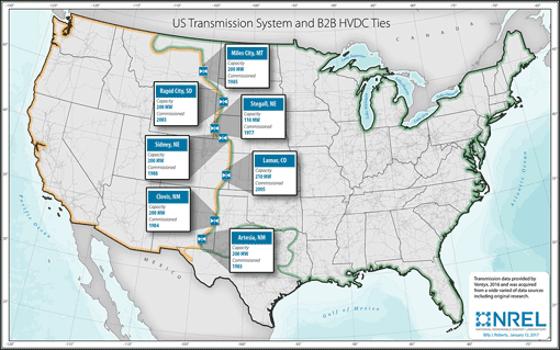
B2B High Voltage DC Ties | |||||
| B2B High Voltage DC Ties | Horizon Climate Group, 2025, based on NREL and US DOE | Elizabeth Abramson, Horizon Climate Group, US B2B High Voltage DC Ties shapefile, based on NREL and US DOE, April 2025, ourgridfuture.org | April 2025 |
NREL
 US DOE
|
Download |
NIETC Corridors | |||||
| NIETC Corridors | US DOE | U.S. Department of Energy, Grid Deployment Office, “Phase 3 Potential National Interest Electrical Transmission Corridors (December 16, 2024),” December 16, 2024, https://gem.anl.gov/tool. Modified by Horizon Climate Group, 2025, ourgridfuture.org. | December 16, 2024 |
View Source
|
Download |
Regional Transmission Organizations | |||||
| Regional Transmission Organizations | ORNL, LANL, INL, NGA & HSIP | Oak Ridge National Laboratory (ORNL), Los Alamos National Laboratory (LANL), Idaho National Laboratory (INL), National Geospatial-Intelligence Agency (NGA), Homeland Security Infrastructure Program (HSIP) Team, Independent System Operators, November 8, 2021, https://hub.arcgis.com/datasets/50f80920d36e435d9a34db2bd0fd3ad8_0/about. Modified by Horizon Climate Group, 2025. | November 8, 2021 |
View Source
|
Download |
Electric Utility Territories | |||||
| Electric Utility Territories | ORNL, LANL, INL, NGA & HSIP | Oak Ridge National Laboratory (ORNL), Los Alamos National Laboratory (LANL), Idaho National Laboratory (INL), National Geospatial-Intelligence Agency (NGA) Homeland Security Infrastructure Program (HSIP) Team, Electric Retail Service Territories, November 8, 2021, https://atlas.eia.gov/datasets/f4cd55044b924fed9bc8b64022966097_0/about. Modified by Horizon Climate Group, 2025. | November 8, 2021 |
View Source
|
Available Soon |
NERC Regions | |||||
| NERC Regions | US Energy Information Administration (EIA) and North American Electric Reliability Corporation (NERC) |
Elizabeth Abramson, Horizon Climate Group, NERC Regions shapefile, based on US EIA and North American Electric Reliability Corporation, April 2025, ourgridfuture.org. | April 2025 |
EIA
|
Download |
Interconnection Seams | |||||
| Interconnection Seams | US Energy Information Administration (EIA) and North American Electric Reliability Corporation (NERC) |
Elizabeth Abramson, Horizon Climate Group, Interconnection Seams shapefile, based on US EIA and North American Electric Reliability Corporation, April 2025, ourgridfuture.org. | April 2025 |
EIA
|
Download |
Electric Generation Plants | |||||
| Electric Generation Plants | EPA eGRID 2022 | US Environmental Protection Agency, Emissions & Generation Resource Integrated Database (eGRID), 2022 data, January 2024, https://www.epa.gov/egrid. Modified by Horizon Climate Group, 2025, ourgridfuture.org. | January 2024 |
View Source
|
Download |
Wind Electricity Projects | |||||
| Wind Electricity Projects | United States Wind Turbine Database v7.0 | Hoen, B.D., Diffendorfer, J.E., Rand, J.T., Kramer, L.A., Garrity, C.P., and Hunt, H.E., 2018, United States Wind Turbine Database v7.0 (May 10, 2024): U.S. Geological Survey, American Clean Power Association, and Lawrence Berkeley National Laboratory data release, https://doi.org/10.5066/F7TX3DN0. | May 10, 2024 |
View Source
|
Download |
Solar Electricity Projects | |||||
| Solar Electricity Projects | United States Large-Scale Solar Photovoltaic Database v1.0 | Fujita, K.S., Ancona, Z.H., Kramer, L.A., Straka, M., Gautreau, T.E., Garrity, C.P., Robson, D., Diffendorfer, J.E., and Hoen, B., 2023, United States Large-Scale Solar Photovoltaic Database v1.0 (November, 2023): U.S. Geological Survey and Lawrence Berkeley National Laboratory data release, https://doi.org/10.5066/P9IA3TUS. | November 2023 |
View Source
|
Download |
Urban Areas | |||||
| Urban Areas | US Census Bureau | US Census Bureau, Geography Division, 2022 TIGER/Line Shapefiles: Urban Areas (2020), January 6, 2023, https://www.census.gov/cgi-bin/geo/shapefiles/index.php?year=2022&layergroup=Urban+Areas. Modified by Horizon Climate Group, 2025. | January 6, 2023 |
View Source
|
Download |
US Counties | |||||
| US Counties | Horizon Climate Group, 2025, based on US Census Bureau | Elizabeth Abramson, Horizon Climate Group, Adapted 2018 Cartographic Boundary Files, based on US Census Bureau, April 2025, ourgridfuture.org. | April 2025 |
2018
|
Download |
Tribal & Indigenous Lands | |||||
| Tribal & Indigenous Lands | US Census Bureau | US Census Bureau Geography Division 2024 TIGER/Line® Shapefiles, American Indian/Alaska Native/Native Hawaiian Areas, 2024, https://www.census.gov/cgi-bin/geo/shapefiles/index.php?year=2024&layergroup=American+Indian+Area+Geography. | September 25, 2024 |
View Source
|
Download |
Disadvantaged Communities | |||||
| Disadvantaged Communities | Council on Environmental Quality (CEQ) | Council on Environmental Quality, Climate and Economic Justice Screening Tool Version 2.0, December 2024, hosted by the Public Environmental Data Project, https://edgi-govdata-archiving.github.io/j40-cejst-2/en/. Modified by Horizon Climate Group, 2025. | December 2024 |
View Source
|
Download |
National, State, and Regional Parks | |||||
| National, State, and Regional Parks | Esri and TomTom North America | Esri and TomTom North America, Inc., USA Parks, October 14, 2024, https://www.arcgis.com/home/item.html?id=578968f975774d3fab79fe56c8c90941. | October 14, 2024 |
View Source
|
Download |
BLM Managed Lands | |||||
| BLM Managed Lands | US Bureau of Land Management (BLM) | Bureau of Land Management, BLM National SMA Surface Management Agency Area Polygons, November 1, 2023, https://gbp-blm-egis.hub.arcgis.com/datasets/blm-national-sma-surface-management-agency-area-polygons/about. | November 1, 2023 |
View Source
|
Download |
BLM Administrative Units | |||||
| BLM Administrative Units | US Bureau of Land Management (BLM) | US Bureau of Land Management, BLM Administrative Unit Boundaries and Office Locations, accessed March 19, 2025, https://gis.blm.gov/arcgis/rest/services/admin_boundaries/BLM_Natl_AdminUnit/MapServer. Modified by Horizon Climate Group, 2025. | March 19, 2025 |
View Source
|
Download |
Critical Habitat for Threatened & Endangered Species | |||||
| Critical Habitat for Threatened & Endangered Species |
US Fish & Wildlife Service | US Fish & Wildlife Service Environmental Conservation Online System (ECOS), Critical Habitat for Threatened & Endangered Species, January 7, 2025, https://ecos.fws.gov/ecp/report/table/critical-habitat.html. | January 7, 2025 |
View Source
|
Download |
Basemaps | |||||
| OpenStreetMap Default Basemap | Open Street Map | Open Street Map, Default Basemap, 2025 | 2025 |
Link
|
|
| USGS TNM Topo Base Map | United States Geological Survey (USGS) | United States Geological Survey, USGS TNM Topo Base Map, February 2025, https://basemap.nationalmap.gov/arcgis/rest/services/USGSTopo/MapServer/. | February 2025 |
Link
|
|
| OpenTopoMap | Stefan Erhardt, Friedrich-Alexander University Erlangen-Nuremberg | Stefan Erhardt, OpenTopoMap, January 22, 2023 | January 22, 2023 |
Link
|
|
| Open Street Map Humanitarian Basemap | Open Street Map | Open Street Map, Humanitarian Basemap, 2025 | 2025 |
Link
|
|
| NASA GIBS VIIRS Earth at Night 2012 | Global Imagery Browse Services (GIBS), operated by the NASA/GSFC/Earth Science Data and Information System with funding provided by NASA/HQ | GIBS, NASA, VIIRS Earth at Night, 2012 | 2012 |
Link
|
|
| World Terrain Base | Esri, USGS, NOAA | Esri, United States Geological Survey, and National Oceanic and Atmospheric Administration, World Terrain Base, May 2020, https://www.arcgis.com/home/item.html?id=c61ad8ab017d49e1a82f580ee1298931. | May 27, 2020 |
Link
|
|
| World Topo Map | Esri, HERE, Garmin, Intermap, increment P Corp., GEBCO, USGS, FAO, NPS, NRCAN, GeoBase, IGN, Kadaster NL, Ordnance Survey, Esri Japan, METI, Esri China (Hong Kong), OpenStreetMap contributors, and the GIS User Community | Esri, HERE, Garmin, Intermap, increment P Corp., GEBCO, USGS, FAO, NPS, NRCAN, GeoBase, IGN, Kadaster NL, Ordnance Survey, Esri Japan, METI, Esri China (Hong Kong), OpenStreetMap contributors, and the GIS User Community, World Topo Map, January 2024, https://www.arcgis.com/home/item.html?id=30e5fe3149c34df1ba922e6f5bbf808f. | January 3, 2024 |
Link
|
|
| USA Topo Maps | National Geographic Society, i-cubed | National Geographic Society and i-cubed, USA Topo Maps, April 2019, https://www.arcgis.com/home/item.html?id=99cd5fbd98934028802b4f797c4b1732. | April 18, 2019 |
Link
|
|
| Carto Light / Positron | CartoDB | CartoDB, Positron Basemap, 2018 | 2018 |
Link
|
|
| Carto Dark / Dark Matter | CartoDb | CartoDB, Dark Matter Basemap, 2018 | 2018 |
Link
|
|
| Google Maps Satellite Imagery | Google Maps | Google Maps, Satellite Imagery, 2025 | 2025 |
Link
|
|
| Google Maps Terrain Layer | Google Maps | Google Maps, Terrain Layer, 2025 | 2025 |
Link
|
|
About Our Grid Future
close page x
April 2025
Our Grid Future
, 2025, is developed and maintained by Horizon Climate Group
.
Project development and data collection on planned transmission projects was conducted in association with
Horizon Climate Group
and Great Plains Institute
. The project team would like to thank Aparna Narang and Hella Cohen for their collaboration.
Authors
| Software development and design: | Dane McFarlane |
| Research and GIS analysis: | Elizabeth Abramson |
| Additional outreach: | Diana Gastelum, Maya Chiclote, and Matt Prorok |
Suggested Citation:
For the planned transmission data layer:
Abramson, E., McFarlane, D., Gastelum, D., Prorok, M., Chilcote, M., Our Grid Future Planned Transmission Projects National Database, Horizon Climate Group, April 2025
For maps, data layers, and other information:
Horizon Climate Group, Our Grid Future, April 2025.
http://www.ourgridfuture.org
http://www.ourgridfuture.org
Planned Transmission Projects
GIS Data Layer
April 2025
close page x
The Our Grid Future Planned Projects layer was created by Elizabeth Abramson and Dane McFarlane, Horizon Climate Group, 2025, in coordination with Matthew Prorok, Diana Gastelum, and Maya Chilcote, Great Plains Institute.
Goal
Create and share a geographic database of planned high-capacity electric transmission lines in the United States.
Rationale
Creating, maintaining, and publishing the planned transmission projects data layer is meant to:
- Build solutions to beneficial transmission planning
- Enable greater transparency and early engagement of stakeholders
- Work constructively to solve siting issues early on
- Help the advocacy community identify priorities for planning and permitting work
- Allow users to see where in the country transmission planning has already occurred at scale and where it has not
Included Projects
The planned projects layer is focused on high-voltage transmission expansion and new system capacity, which are key to enabling:
- Regional and national electric decarbonization
- Economic growth
- Grid resilience
- 230 kV or higher
- New lines
- Line upgrades
- Line rebuilds
- Line reconductoring projects
Authors
| Research and GIS analysis: | Elizabeth Abramson |
| Research and outreach: | Diana Gastelum, Maya Chilcote, and Matt Prorok |
| Software development and design: | Dane McFarlane |
Suggested Citation
Abramson, E., McFarlane, D., Gastelum, D., Prorok, M., Chilcote, M., Our Grid Future Planned Transmission Projects National Database, Horizon Climate Group, April 2025
|
|
||
|
Transmission Regions
US BLM Lands
States & Counties
|
|
|||||||||||||||
|
Basemap
|
Electric Transmission
Electric Substations
Electric Utilities
Natural Lands
Communities
|
||||||||||||||
+
–
Created by
Horizon Climate Group, 2025
Horizon Climate Group, 2025
Loading
cancel x
Download the database:
To access the planned transmission shapefile and database, please provide your contact information.
Your information will NOT be shared publicly, and will only be used to measure the use of Our Grid Future.
By downloading the database, you agree to use the following citation in any published work or presentation where it is utilized:
Abramson, E., Gastelum, D., Prorok, M., McFarlane, D., Chilcote, M., Our Grid Future Planned Transmission Projects National Database, Horizon Climate Group, April 2025